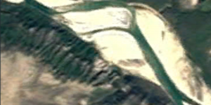


I've always been fascinated with satellite photos; this completely new method of understanding space, completely new perspective on the earth. How do we interact with our planet now that we have a photographic archive of practically every area of the globe? I grew interested in how space is organised numerically, the abstract digits of Decimal Coordinates which represent physical place. I found the coordinates of my childhood and current dwelling, added one decimal unit to the latitude coordinate, effectively moving one unit north. I screenshoted the satellite photograph which Google Earth output, and repeated until I reached the Arctic Ocean. I continued for an equal amount of photographs South, placing me well within the Pacific Ocean. The result is a documentation of a slice of Earth, the -123.1450222rd Meridian through individual places. These places share a numerical relationship to my home, but no other tangible relationship. The piece speaks for itself, raising questions about urbanization in a colonized society, surveillance culture, and our relationships to the spaces we call home.
In March of 2018, I had the opportunity to present this project at CAPCON; UBC's showcase for the Co-ordinated Arts Program.
Learning Significance